
TerraEye Launches 2.0, a Targeting Platform for Mineral Exploration in Difficult Terrain
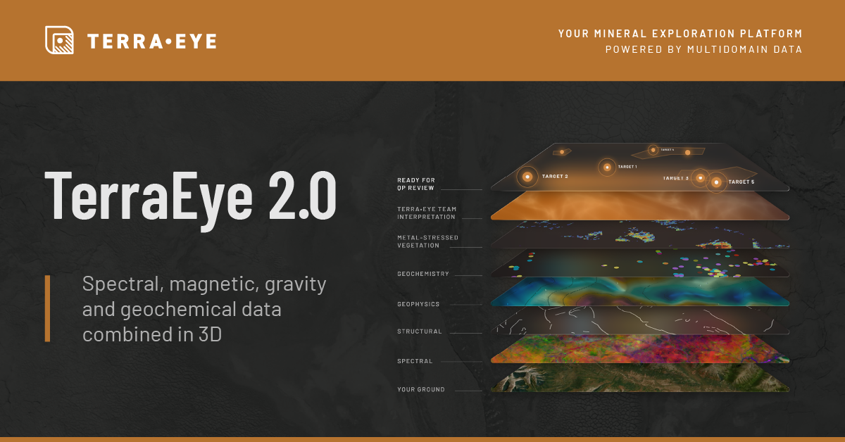
TerraEye 2.0. release

Dr. Wojciech Kuloza-Kaczan, Head of Product at TerraEye
The release brings satellite, geophysical and geochemical data into one workspace to help exploration teams prioritize targets and field budgets.
For the first time, I can put the magnetics next to the spectra and watch the same anomaly show up in both. That overlap is what you want in hand before you commit a field season.”
WROCłAW, POLAND, September 8, 2026 /EINPresswire.com/ -- TerraEye today announced the launch of TerraEye 2.0, bringing satellite imagery, geophysical data and geochemical results into a single mineral exploration targeting workspace. The release helps exploration teams compare evidence and prioritize targets before committing to fieldwork or drilling.— Dr. Wojciech Kuloza-Kaczan, Head of Product at TerraEye
Built for teams with more ground than budget, the platform supports exploration on remote projects with limited rock exposure and short field seasons. Geologists can bring in data they already own, assess where datasets support or challenge a target, and trace the interpretation back to its source data and analysis methods.
"For the first time I can put the magnetics next to the spectra and watch the same anomaly show up in both," said Wojciech Kuloza-Kaczan, TerraEye's Head of Product. "That overlap is what you want in hand before you commit a field season."
TerraEye 2.0 also introduces Analogy Lab, which lets users search for areas with spectral signatures similar to selected reference locations, including known deposits. The redesigned workspace allows teams to view satellite and uploaded exploration data together over the terrain in 3D.
TerraEye selects its remote-sensing methods to suit surface conditions. On exposed ground, it maps surface alteration signatures using hyperspectral and multispectral imagery, including EMIT, EnMAP, ASTER and Sentinel-2. In forested areas, vegetation-stress analysis can provide an additional, indirect indicator to assess alongside geological, geophysical and geochemical evidence.
An independent regional assessment also examined TerraEye’s metal-stressed vegetation index. In Mining Potential of Northern Ontario’s Ring of Fire, a July 2026 report prepared for the Regional Assessment Working Group by R. Mohan Srivastava, Alan Lambden and Petr Cizek, the index provided the strongest initial separation between locations with and without rock samples exceeding 2% nickel. The analysis used outcrop and drill-hole assay data and assessed predictors including magnetic and gravity data.
In a separate screening program for BMRC / International Resources Holding (IRH), TerraEye assessed approximately 97,300 km² using satellite analysis and existing exploration data, delivering 51 ranked targets for field follow-up. These included 15 targets within an equatorial area of more than 53,000 km² under near-continuous forest cover.
TerraEye 2.0 is available now. Scout starts at US$9,700 per year for a single geologist working one property. Explorer starts at US$33,900 per year for teams with active drilling programs, while Professional starts at US$83,500 per year for portfolios spanning multiple jurisdictions. Project-based analysis services are available separately.
About TerraEye
TerraEye is an AI-driven mineral exploration company that turns multispectral and hyperspectral satellite data into ranked, field-ready exploration targets. The TerraEye Platform combines advanced spectral analytics, proprietary vegetation-stress methods for covered terrain, and integrated geoscientific interpretation to de-risk early-stage exploration decisions. TerraEye is a trademark of Remote Sensing Business Solutions, headquartered in Wrocław, Poland. Learn more at terraeye.co.
Marek Wilgucki
TerraEye
marek.wilgucki@terraeye.co
Visit us on social media:
LinkedIn
Legal Disclaimer:
EIN Presswire provides this news content "as is" without warranty of any kind. We do not accept any responsibility or liability for the accuracy, content, images, videos, licenses, completeness, legality, or reliability of the information contained in this article. If you have any complaints or copyright issues related to this article, kindly contact the author above.
